Friday, February 22, 2019

Seismic Activity


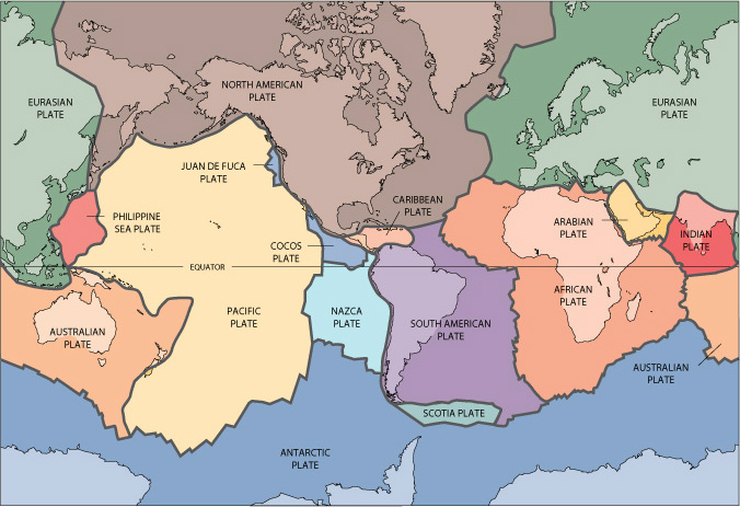
           Colombia is very seismically active which makes it a very interesting place to discuss the natural hazard: earthquakes. The picture included above shows where most of the earthquakes occur and as you can see the most risk is associated with the western side of the country. Notice that the area with the most seismicity is where the Nazca Plate meets the South American Plate on the western coast of Colombia, in the Andean mountain range that passes through the country and splits in two directions. Since 1995 there have been 9 major earthquakes with many smaller ones in between. The most seismically active region in Colombia experiences close to 40 tremors per day, everyday.  

          Colombia has put many measures into place to try to mitigate the hazards associated with earthquakes including stricter building codes implemented in 1984, 1998, and 2010. The new buildings that are officially constructed are much safer and seismically resistant; however, only about one third of the building being built are built "officially". This is happening because the current building codes are expensive and difficult to enact with many steps and paperwork to work through. Many homes are built because of necessity and an inability to wait for a long "official" process, therefore, many Colombians are living in unsafe housing. Efforts are still currently being made to make the implementation of safer buildings more feasible. For example a program with Caja de la Vivienda Popular and the Habitat Secretariat is working to train Engineers and construction workers in safer building methods with public and private investments in order to reinforce existing structures and build new buildings. This is now being tested in Bogotá and MedellĂ­n and if successful will be implemented on a larger scale. 


Also a interesting note to add about Colombia's seismicity is the phenomena illustrated in the figure above.  Due to it's bordering three tectonic plates, Colombia experiences a rare occurrence which geologist are calling the "Caldas tear". In this article (https://phys.org/news/2013-06-caldas-puzzling-seismic-beneath-colombia.html) they explain this phenomena really well and I suggest it as a good read. 

Sunday, February 10, 2019

Colombia and Plate Boundaries


In order to discuss Colombia's relationship with plate tectonic borders, first we must orient ourselves with it's geographic location. Colombia is located in South America, south of Panama, northeast of Ecuador and Peru, north of Brazil, and west of Venezuela. It is also bordered by the Caribbean Sea to the north and the Pacific Ocean to the west. The Equator runs along it's southern border and therefore is located in the tropics. The image below illustrates this description.

Fig. 1

The Plate Tectonic Theory explains that earth's crust is sectioned into many rigid lithospheric plates which move slowly over the underlying mantle and interact with each other resulting in an array of associated phenomenon. Below is pictured the known tectonic plates of the earth. 

Fig. 2


As you can see from Fig. 2, Colombia is located on the South American Plate and near the border with the Caribbean Plate and Nazca Plate. The location of the country will affect the types hazards that will be associated with it depending on the interaction between the tectonic plates. The figure below shows the direction that the plates surrounding Colombia are moving. The interaction between the Caribbean Plate and the South America Plate is minimal because that are both moving in the same direction. The interaction between the Nazca and the South America Plate, however, is different. These two plates are converging with the Nazca oceanic plate sub-ducting beneath the South America Plate. This subduction creates earthquakes and volcanoes further inland. 

Fig. 3
https://www.google.com/url?sa=i&source=images&cd=&ved=2ahUKEwjW7qL6hrDgAhVPS60KHTI_BV4QjRx6BAgBEAU&url=https%3A%2F%2Fgeology.com%2Fvolcanoes%2Farenal%2F&psig=AOvVaw3d8zD-JNnD2KkC1RNxCXcJ&ust=1549849890942831

The figure below shows the volcanoes in Colombia. As you can see the line of volcanoes correlates with the plate boundary to the west. When one plate converges with another to form a subduction zone one will see the occurrence of volcanoes a few miles inland because the sub-ducting plate reaches a point where it begins to melt and turn into hot magma. That hot magma eventually rises to release pressure and this creates the volcanoes. Depending on the angle at which the sub-ducting plate is moving underneath the other tectonic plate will directly determine the distance inland at which the volcanos will be located.

Fig. 4
https://www.google.com/url?sa=i&source=images&cd=&ved=2ahUKEwjGov_bhLDgAhVJKawKHYHZAbQQjRx6BAgBEAU&url=%2Furl%3Fsa%3Di%26source%3Dimages%26cd%3D%26ved%3D%26url%3Dhttps%253A%252F%252Fen.wikipedia.org%252Fwiki%252FAndean_Volcanic_Belt%26psig%3DAOvVaw25j1eP3p3QXKlP-5m_UW_C%26ust%3D1549849296538542&psig=AOvVaw25j1eP3p3QXKlP-5m_UW_C&ust=1549849296538542

On a more global scale I think it is important to note that Colombia is also located next to the "Ring of Fire" that encircles the pacific ocean. The Ring of Fire is a major area in the basin of the Pacific Ocean where many earthquakes and volcanic eruptions occur.

Fig. 5
https://www.google.com/url?sa=i&source=images&cd=&cad=rja&uact=8&ved=2ahUKEwjD68-RirDgAhULKawKHS4TDLcQjRx6BAgBEAU&url=https%3A%2F%2Fwww.nbc-2.com%2Fstory%2F25149324%2Fexperts-strict-building-codes-saved-lives-in-powerful-chile-earthquake&psig=AOvVaw22JHPC-jxPkgIcdX_NPdr8&ust=1549850695468794


Colombia also experiences other hazards like flooding and landslides that are sometimes products of or made worse by earthquakes and volcanoes. Despite having so many hazards, Colombia is also one of the leading countries in the world taking steps to prevent the effects these natural hazards have on the population and property. This helps to prevent these natural hazards from turning into disasters or catastrophes.

Friday, February 1, 2019

Natural Hazards, Disasters, and Catastrophes

My purpose in this blog will be to discuss natural hazards,  disasters, and catastrophes, specifically focusing on examples in the country of Colombia.

A natural hazard is a natural process on earth that involves a potential threat to human life and property. Some examples that occur in Colombia are earthquakes and volcanoes since it is situated on the Pacific Ring of Fire and is part of the Andean Volcanic Belt. The following graphic shows where the Andean Volcanic Belt is located. Notice that the Northern Volcanic Zone passes through from Ecuador north into Colombia.


When a hazardous event happens over a limited time frame and either ten or more people die, one-hundred or more people are affected, a state of emergency is declared,  or international help is requested, it is classified as a disaster. An example of a disaster occurring in Colombia is the Tumaco earthquake in 1979.  It was a 8.2 magnitude earthquake which caused an tsunami that killed around 450 people. As you can see from the graphic, it occurred on the western coast near Ecuador.


A disaster that requires many years and a significant amount money to recover from is classified as a catastrophe. An example in Colombia was the eruption of the Nevado del Ruiz in 1985 which caused mudflows, landslides, and debris flows from the melted ice caps and killed 23, 000 people. Shown below is a photo the exploding volcano and the flooded city of Armero afterwards.


This a good place to start in understanding the differences in definitions. I look forward to going into more detail with these subjects over the next coming months.