In order to discuss Colombia's relationship with plate tectonic borders, first we must orient ourselves with it's geographic location. Colombia is located in South America, south of Panama, northeast of Ecuador and Peru, north of Brazil, and west of Venezuela. It is also bordered by the Caribbean Sea to the north and the Pacific Ocean to the west. The Equator runs along it's southern border and therefore is located in the tropics. The image below illustrates this description.
Fig. 1

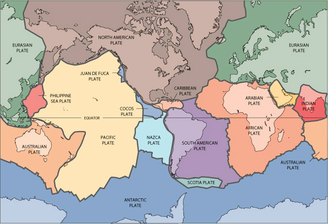
The Plate Tectonic Theory explains that earth's crust is sectioned into many rigid lithospheric plates which move slowly over the underlying mantle and interact with each other resulting in an array of associated phenomenon. Below is pictured the known tectonic plates of the earth.
Fig. 2

As you can see from Fig. 2, Colombia is located on the South American Plate and near the border with the Caribbean Plate and Nazca Plate. The location of the country will affect the types hazards that will be associated with it depending on the interaction between the tectonic plates. The figure below shows the direction that the plates surrounding Colombia are moving. The interaction between the Caribbean Plate and the South America Plate is minimal because that are both moving in the same direction. The interaction between the Nazca and the South America Plate, however, is different. These two plates are converging with the Nazca oceanic plate sub-ducting beneath the South America Plate. This subduction creates earthquakes and volcanoes further inland.
Fig. 3

The figure below shows the volcanoes in Colombia. As you can see the line of volcanoes correlates with the plate boundary to the west. When one plate converges with another to form a subduction zone one will see the occurrence of volcanoes a few miles inland because the sub-ducting plate reaches a point where it begins to melt and turn into hot magma. That hot magma eventually rises to release pressure and this creates the volcanoes. Depending on the angle at which the sub-ducting plate is moving underneath the other tectonic plate will directly determine the distance inland at which the volcanos will be located.
Fig. 4

On a more global scale I think it is important to note that Colombia is also located next to the "Ring of Fire" that encircles the pacific ocean. The Ring of Fire is a major area in the basin of the Pacific Ocean where many earthquakes and volcanic eruptions occur.
Fig. 5

Colombia also experiences other hazards like flooding and landslides that are sometimes products of or made worse by earthquakes and volcanoes. Despite having so many hazards, Colombia is also one of the leading countries in the world taking steps to prevent the effects these natural hazards have on the population and property. This helps to prevent these natural hazards from turning into disasters or catastrophes.
Very nice overview and setting for the course. Looking forward to hearing specifically about quakes...
ReplyDelete