Friday, April 12, 2019

Severe Storms and Lightening

https://notiespartano.com/2017/12/30/murieron-dos-soldados-impacto-rayo-catatumbo/


Colombia is a country located in the tropics and respectively has an abundant amount of rainfall every year; however, it is particularly susceptible to severe storms and lightening. In 2010 Colombia was listed as the third most affected country by extreme weather according to European NGO, German watch. Lake Maracaibo in Venezuela, near the border with Colombia holds the world record for the most lightening place struck on earth, receiving an average of 233 lightening strikes per square km per year. This region is so susceptible to lightening because the cool air from the Andes mountains converges with the warm air from the coast to form many thunderstorms every year.

Lightening over Lake Maracaibo
https://www.univision.com/noticias/medio-ambiente/el-catatumbo-la-nueva-capital-de-los-rayos-en-el-mundo

These storms present truly magnificent displays of lightening dancing across the skies, striking with the awesome power of the wild nature of the tropics. Unfortunately this is not all they do. During the wet season (May to November) it can rain tremendously for days and weeks without stopping. On June 9th and 10th of 2016 severe storms affected much of northern Colombia. During just a 24 hour period Earth Networks Total Lightning Network detected over 70,000 lightning strikes across the country which prompted 23 Dangerous Thunderstorm Alerts (DTA’s), a unique severe weather warning exclusive to Earth Networks.

These massive storms also cause destruction of farmlands. In the storm of June 9th and 10th, 2016 much of the livestock died along with cultivations of beans, corn, peas, paprika, passion fruit, avocado, onion, tomato and bananas in Capitanlargo. Farmers from the villages of El Rosario, Paloquemao, El Potrero, La Rojas, Llanitos, Bellavista and Gallinetas lost all of their crops.


http://www.banastat.com/banana-loses-in-colombia-push-up-the-international-markets/
Heavy rains can also cause mass wasting which I discussed in a previous post how devastating this can be to people, property, and the natural environment. In the picture below you can see a large landslide that occurred in Choco due to the aforementioned thunderstorm. This specific landslide killed 8 people and left 30 missing. 

https://www.earthnetworks.com/blog/severe-storms-colombia/

As to what Colombia is doing to mitigate the affects of these tremendous storms on their people and economy, the NGO warned in 2010 that Colombia needed to strengthen its defenses against winter rains which that year left over two million people without homes. Colombia is one of the most susceptible countries in the world to extreme weather conditions due to it's geographical location and unique weather conditions. In the past 10 years they have made great strides to implement disaster risk reduction policies. They continue to renew and revise policies, set up evacuation plans, educate the public, and put out warnings for disasters. Though there is still progress to be made, Colombia is making great leaps despite limited economic resources. "Our priority is to save lives and we will not rest until the emergency is overcome," stated the previous president, Juan Manuel Santos, when he addressed the 6th Regional Platform on Disaster Risk Reduction in the Americas. “Today, we can state that the country is much more prepared to answer any emergency it faces. We have good systems of coordination.”

https://www.unisdr.org/archive/58870

https://www.accuweather.com/en/weather-news/central-south-america-colombia-flooding-natural-disasters-volcano-eruptions/47826395

https://colombiareports.com/colombia-tops-list-of-countries-affected-by-severe-weather/

Thursday, March 28, 2019

Mass Wasting in Colombia

Landslide Mocoa April 1, 2017

Colombia is one of the most landslide-prone places in the world, with mountains, volcanoes, earthquakes, weathering and an intense rainy season all combining to create a terrain very susceptible to mass wasting. A majority of the landslides that occur in Colombia are in the mountainous western region of the country (as you can see in the image below from NASA's Disaster Program).


          A recent and devastating example is the 2017 Landslide that occurred on the first of April in Mocoa, Putumayo. Heavy rains triggered the flash floods and landslides that killed 254 people, injured 332, and left 70 missing. Soldiers, police officers, and red cross members worked side by side with the citizens to try to rescue survivors. Many were left with nothing, their houses and livelihoods destroyed. The government has spent hundreds of thousands of dollars on temporary housing for displaced peoples. This catastrophe is remembered as the third largest in Colombian history. 

Mudslide Mocoa April 1, 2017

In Colombia triggers for mass wasting will always exist and there is very little humans can do to stop landslides. There are, however, ways to mitigate the effects. Better city planning, early warning systems, and not building near danger zones would help prevent disasters. According to a 2006 report from the International Association for Engineering Geology and the Environment, "The Colombian government implements landslide monitoring, mitigation and stabilization programs. These include improved methods for mining subsidence prediction, better building control, improved engineering practice and communications. With landslide hazard mapping, risks and vulnerability maps are now available for major urban areas." However, it tends to be the poor and marginalized groups that live in the areas most susceptible to mass wasting, in pop-up towns on steep ridges on the out-skirts of cities. These buildings are usually built unofficially and out of code and are very susceptible to damage from mass wasting. Every year an average of 100 Colombian citizens die from landslides and there is no evidence of this slowing down over the years. The government has been working since 2011 making reforms to environmental management, but they have failed to enact anything yet.
There do seem to be private systems of warning though. For example, one may sign up for notifications for the latest weather hazards through a Colombian service provided by IDEAM (Instituto de Hidrología, Meteorología, y Estudios Ambientales) online and with an app called Mi Pronóstico which provides updates twice a day for all the regions of Colombia and provides emergency alerts.
April 19, 2017 Manizales 
Below are some interesting papers I read in my research that may be of interest.

https://www.issmge.org/uploads/publications/1/32/1994_06_0013.pdf
https://www.alnap.org/system/files/content/resource/files/main/iaeg-112.pdf
https://thebogotapost.com/mocoa-preventing-future-disaster/21536/

Friday, March 1, 2019

"Los Volcanes Dormidos"


            There are 15 volcanoes in Colombia that are considered active with the most recent eruptions occurring at Galeras in 2014 and Nevado del Ruiz in 2012. As you can see from the image above they follow a line parallel to the plate boundary to the west and the Andean Mountain Range. The volcanoes in Colombia are part of a longer line of volcanoes, the Andes cordillera, that stretches from Argentina to Colombia. 


           These volcanoes are created through the subduction of the oceanic Nazca Plate beneath the continental South American Plate. The oceanic plate contains molecules of water and mineral deposits. When the oceanic crust melts it creates magma with a high volatile content. The resulting volcanoes that are formed along this subduction zone are stratovolcanoes. These volcanoes have more explosivity because when the eruption occurs the pressure that has built up with the volatiles is released. These volcanoes have more viscous lava that can not travel very far before cooling and becoming solid, therefore, these volcanoes have a cone shape and can create very high mountain ranges. The average height along the Andes Cordillera is 4000m with it's highest peak at 6962m.

The Nevada de Ruiz 1985


                In 1985 one of the most devastating volcanic eruptions for the country of Colombia transpired in the Nevado del Ruiz, which stands at 5300m tall and is covered with glacial ice.  When the explosion occurred, glacier melts mixed with the mud creating a massive lahar that engulfed part of the town of Armero the night of November 13,1985, killing nearly 20,000 of the 29,000 inhabitants of the city in their sleep. The mud was so viscous that it was nearly impossible to provide relief to the remaining citizens. The world remembers the video and images of Omayra Sánchez seen, a 13 year old girl who died slowly in the viscous mud unable to be rescued.


             In total 23,000 people died and around 5,000 were injured. Unfortunately this catastrophe was made worse by the fact that this event was predicted by geologist that alerted the authorities and media but the people did not realize the real danger. There was also a strong storm the same day of the explosion that inhibited communication and most people stayed in their homes as they were instructed. Evacuation maps were made but they were poorly distributed. Because of this event, the people of Colombia have learned a hard lesson about the "volcán dormido" in their midst. This means "sleeping volcano" and the saying comes from the fact that stratovolcanoes can stay dormant for a long time before exploding, like this one did, for 69 years. The Colombian government has now set up a specialized office that promotes natural hazard awareness and are working with the US government to provide resources to better prepare and respond to natural hazards such as these. The volcanoes are being monitored everyday. In addition to this, many cities near the volcanoes have their own programs to raise awareness and educate people with disaster plans.

Friday, February 22, 2019

Seismic Activity


           Colombia is very seismically active which makes it a very interesting place to discuss the natural hazard: earthquakes. The picture included above shows where most of the earthquakes occur and as you can see the most risk is associated with the western side of the country. Notice that the area with the most seismicity is where the Nazca Plate meets the South American Plate on the western coast of Colombia, in the Andean mountain range that passes through the country and splits in two directions. Since 1995 there have been 9 major earthquakes with many smaller ones in between. The most seismically active region in Colombia experiences close to 40 tremors per day, everyday.  

          Colombia has put many measures into place to try to mitigate the hazards associated with earthquakes including stricter building codes implemented in 1984, 1998, and 2010. The new buildings that are officially constructed are much safer and seismically resistant; however, only about one third of the building being built are built "officially". This is happening because the current building codes are expensive and difficult to enact with many steps and paperwork to work through. Many homes are built because of necessity and an inability to wait for a long "official" process, therefore, many Colombians are living in unsafe housing. Efforts are still currently being made to make the implementation of safer buildings more feasible. For example a program with Caja de la Vivienda Popular and the Habitat Secretariat is working to train Engineers and construction workers in safer building methods with public and private investments in order to reinforce existing structures and build new buildings. This is now being tested in Bogotá and Medellín and if successful will be implemented on a larger scale. 


Also a interesting note to add about Colombia's seismicity is the phenomena illustrated in the figure above.  Due to it's bordering three tectonic plates, Colombia experiences a rare occurrence which geologist are calling the "Caldas tear". In this article (https://phys.org/news/2013-06-caldas-puzzling-seismic-beneath-colombia.html) they explain this phenomena really well and I suggest it as a good read. 

Sunday, February 10, 2019

Colombia and Plate Boundaries


In order to discuss Colombia's relationship with plate tectonic borders, first we must orient ourselves with it's geographic location. Colombia is located in South America, south of Panama, northeast of Ecuador and Peru, north of Brazil, and west of Venezuela. It is also bordered by the Caribbean Sea to the north and the Pacific Ocean to the west. The Equator runs along it's southern border and therefore is located in the tropics. The image below illustrates this description.

Fig. 1

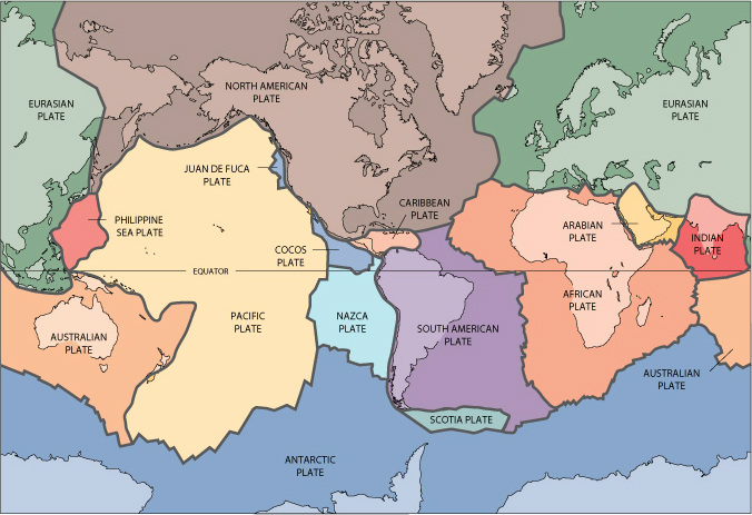
The Plate Tectonic Theory explains that earth's crust is sectioned into many rigid lithospheric plates which move slowly over the underlying mantle and interact with each other resulting in an array of associated phenomenon. Below is pictured the known tectonic plates of the earth. 

Fig. 2


As you can see from Fig. 2, Colombia is located on the South American Plate and near the border with the Caribbean Plate and Nazca Plate. The location of the country will affect the types hazards that will be associated with it depending on the interaction between the tectonic plates. The figure below shows the direction that the plates surrounding Colombia are moving. The interaction between the Caribbean Plate and the South America Plate is minimal because that are both moving in the same direction. The interaction between the Nazca and the South America Plate, however, is different. These two plates are converging with the Nazca oceanic plate sub-ducting beneath the South America Plate. This subduction creates earthquakes and volcanoes further inland. 

Fig. 3
https://www.google.com/url?sa=i&source=images&cd=&ved=2ahUKEwjW7qL6hrDgAhVPS60KHTI_BV4QjRx6BAgBEAU&url=https%3A%2F%2Fgeology.com%2Fvolcanoes%2Farenal%2F&psig=AOvVaw3d8zD-JNnD2KkC1RNxCXcJ&ust=1549849890942831

The figure below shows the volcanoes in Colombia. As you can see the line of volcanoes correlates with the plate boundary to the west. When one plate converges with another to form a subduction zone one will see the occurrence of volcanoes a few miles inland because the sub-ducting plate reaches a point where it begins to melt and turn into hot magma. That hot magma eventually rises to release pressure and this creates the volcanoes. Depending on the angle at which the sub-ducting plate is moving underneath the other tectonic plate will directly determine the distance inland at which the volcanos will be located.

Fig. 4
https://www.google.com/url?sa=i&source=images&cd=&ved=2ahUKEwjGov_bhLDgAhVJKawKHYHZAbQQjRx6BAgBEAU&url=%2Furl%3Fsa%3Di%26source%3Dimages%26cd%3D%26ved%3D%26url%3Dhttps%253A%252F%252Fen.wikipedia.org%252Fwiki%252FAndean_Volcanic_Belt%26psig%3DAOvVaw25j1eP3p3QXKlP-5m_UW_C%26ust%3D1549849296538542&psig=AOvVaw25j1eP3p3QXKlP-5m_UW_C&ust=1549849296538542

On a more global scale I think it is important to note that Colombia is also located next to the "Ring of Fire" that encircles the pacific ocean. The Ring of Fire is a major area in the basin of the Pacific Ocean where many earthquakes and volcanic eruptions occur.

Fig. 5
https://www.google.com/url?sa=i&source=images&cd=&cad=rja&uact=8&ved=2ahUKEwjD68-RirDgAhULKawKHS4TDLcQjRx6BAgBEAU&url=https%3A%2F%2Fwww.nbc-2.com%2Fstory%2F25149324%2Fexperts-strict-building-codes-saved-lives-in-powerful-chile-earthquake&psig=AOvVaw22JHPC-jxPkgIcdX_NPdr8&ust=1549850695468794


Colombia also experiences other hazards like flooding and landslides that are sometimes products of or made worse by earthquakes and volcanoes. Despite having so many hazards, Colombia is also one of the leading countries in the world taking steps to prevent the effects these natural hazards have on the population and property. This helps to prevent these natural hazards from turning into disasters or catastrophes.

Friday, February 1, 2019

Natural Hazards, Disasters, and Catastrophes

My purpose in this blog will be to discuss natural hazards,  disasters, and catastrophes, specifically focusing on examples in the country of Colombia.

A natural hazard is a natural process on earth that involves a potential threat to human life and property. Some examples that occur in Colombia are earthquakes and volcanoes since it is situated on the Pacific Ring of Fire and is part of the Andean Volcanic Belt. The following graphic shows where the Andean Volcanic Belt is located. Notice that the Northern Volcanic Zone passes through from Ecuador north into Colombia.


When a hazardous event happens over a limited time frame and either ten or more people die, one-hundred or more people are affected, a state of emergency is declared,  or international help is requested, it is classified as a disaster. An example of a disaster occurring in Colombia is the Tumaco earthquake in 1979.  It was a 8.2 magnitude earthquake which caused an tsunami that killed around 450 people. As you can see from the graphic, it occurred on the western coast near Ecuador.


A disaster that requires many years and a significant amount money to recover from is classified as a catastrophe. An example in Colombia was the eruption of the Nevado del Ruiz in 1985 which caused mudflows, landslides, and debris flows from the melted ice caps and killed 23, 000 people. Shown below is a photo the exploding volcano and the flooded city of Armero afterwards.


This a good place to start in understanding the differences in definitions. I look forward to going into more detail with these subjects over the next coming months.